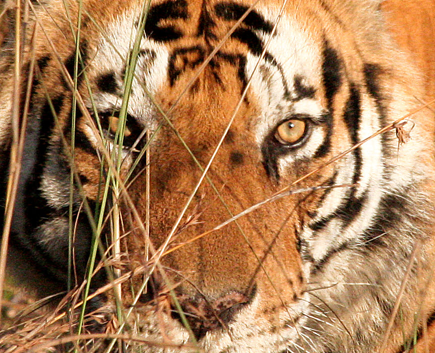
Yes: My photo.
No: Not by 1200mm telephoto lens.
I was perhaps three strides from the thankfully not-hungry Munna, in the back of an open vehicle. Late afternoon. Munna: An eleven year old male. About as big as they get. Name: Munna
(The image is about 2/3rds of the width from an image taken with a 300mm lens.)
Many people and organizations deserve credit for their parts in our fabulous experience. However, I have for far too long failed to get mention of Karen and "PD" into this account. These gentlemen worked incredibly hard and incredibly effectively to make the trip what it was, and were friendly and helpful companions at the same time. Both are Nepalese, and it was a sad shock not long after the trip to hear of the terrible tragedy there, on Everest, in which so many local people died.
The Tropical Ice Passage to India trip, to me, falls into several elements. I should stress two things:
a) I had a great time
b) This description is just one customer's perception of one instance of the program... the one of 23 Feb-13 March, 2014.
To me, the trip seems to fall into the following elements...
I suspect that the main attraction for you, Dear Reader, of this site is the photos. But I hope that some of the text, putting them in context, will be of interest too.
I want to make it easy for you to "look at the pictures"... without too much repetition of specific images.
So here's the plan....
Most pages will be to give each photo one "moment in the sun".
On a few pages, a photo may make a repeat appearance, usually as a small "spot of color", to make the text a bit less dense. Such appearances won't be the photo's "main" appearance.
And there will be a special page, "Best Photos", which will allow a few photos to appear twice on the site: Once on "Best Photos", and once on one of the "category" photo pages. (If someone can suggest a better title than "Best Photos" which would not be too cumbersome, I'd welcome the help. (There is only one "best", so "Best Photos makes no sense, and a page for the best photo would be a bit thin, would it not?)
So... if you visit just the following, you will see all the photos on offer. I hope that the correspondence between the site organization and the trip's elements makes sense to you.
Tiger Encounters
People (Images not appearing on other pages.)
Animals Seen (Images not appearing on other pages.)
Culture- main page
Culture- (detail page: a remote rural community)
Walks
Satpura Game Drive, and Wilderness near Shimla
Travel Days
Lodgings
Luxury
-
EnRoute
EnRouteTwo
The last two pages are special: Eventually, they should wither away to nothing and die, like the scaffolding used in the construction of a building.
Some of the images on this site have had hours... literally... of processing with Serif's excellent PhotoPlus (Windows).... a very usable version is available for a nominal charge. Not many of the photos have had hours of work, but more than one. And most have had at least 5 minutes "polishing". I tend to do the photos in batches, and just "dump" them onto one of the "EnRoute" pages. Later, I move the photos to more logical places.
I hope you will want to read the following pages, too, but any images on them will also appear on one of the pages above....
Trip's main index page.. the page you are reading!
Itinerary Details
... and, as I said before, (special case) on the "Best Photos" page (to be created)
On 20 Feb, in the final throes of packing, I discovered that there were a number of errors in the description on this page, which have been fixed from their original state. Mostly a matter of sequence. The page has also been lightly edited, post trip, to reflect a few sensible modifications which arose along the way, in response to weather, etc. The willingness and ability of Iain and his team to make these modifications was, I think, commendable. You want "predictable"? Stay at home.
Remember: nothing here should be take as "official". And you should expect the Tropical Ice "Passage to India" to evolve, as time passes.
My 2014 trip was my second visit to India. I had a wonderful time on my first trip to India, in 2007. Another trip... if I could find the right package... was on my mind.
What follows on this page has been online for a while; it was my first attempt to describe the trip. Subsequently, I created a new page with more detail. Both it and this page have had "post-trip polish ups".
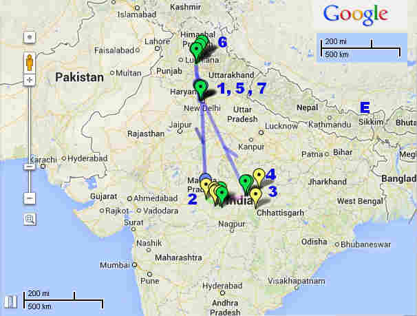
For a zoom-able version of the map, with way-points giving information, visit the Google "My Places" map I've created.
This is just the highlights, remember! Though I haven't mentioned "culture" often in the following list, we did from time to time avail ourselves of chances to see culture during travel days.
While it really has nothing to do with India, in my mind, something else will always be associated with the trip. I am, in a small way, a book collector. Almost as soon as I got back home, I became aware of an amazing catalog of books, all on science (the focus of my collection). Though quite tired from the trip, the catalog repaid careful prompt attention. I've written a page about the catalog, in hopes that I can tempt you to have a look. (It will open in a new window or tab.)
We had a night in a lodge before the walking began, and a visit to a part of the park near the lodge, in vehicles. On that drive, we had an extraordinary "visit" with a sloth bear (think Paddington, though he was, of course, a Peruvian bear) and her cub. We also had a glimpse of the Indian wild dog (Wikipedia), or dhole. A "foxy coyote", to give you an approximation. Social, like wolves and the African wild dog, which has been to kind to me with sightings over the years. About 50 lbs, for a male, shoulder height about 50cm. Now... this may not seem so very special to some, but they are highly nomadic... i.e. hard to see... and officially (IUCN) "endangered". I could find no estimate of the remaining global population, but I think it fair to say that more eco-tourists see tigers than see the Indian wild dog. One rather perverse "ray of hope": They may be doing well in Burma, because the tiger is doing so poorly there, and life is getting "easy" for the dhole, as a result. They are the only living representative of their genus.
Back to the trip!...
We walked in remote areas, staying overnight under (rather luxurious) canvas. Camp will be set up for us, and our bags will "magically" appear by our camp beds... so we weren't really roughing it, carrying everything with us... but we were certainly "far from the madding crowd"!
Wikipedia extract...
Satpura National Park is located in the district Hoshangabad of Madhya Pradesh. It gets its name from the Satpura ranges.It covers an area of 524 km2 (202 sq mi). Satpura National Park, and along with the adjoining Bori and Panchmarhi Sanctuaries, provides 1,427 km2 (551 sq mi) of unique central Indian highland ecosystem.The terrain of the national park is extremely rugged and consists of sandstone peaks, narrow gorges, ravines and dense forests. Satpura National Park, being part of a unique ecosystem, is very rich in biodiversity. The animals here comprise of tiger, leopard, sambar, chital, Bhedki, nilgai, four-horned antelope, chinkara, bison (gour), wild boar, wild dog, bear, black buck, fox, porcupine, flying squirrel, mouse deer, Indian giant squirrel, etc. There are a variety of birds. Hornbills and peafowl are common birds found here.
(End Wikipedia quote). (Details elsewhere of animals we saw.)
(From TI description of plans... While we are in Satpura...)
"We will follow the narrow Denwa river, then hike through the hills, which border our camp, as we penetrate the stunning Sal and Banyan forests. Few outsiders ever visit this section of Satpura, and in 2013 our walking party was the first in the region since Captain J Forsyth of the British army, Bengal Lancers division, made his exploratory journey in 1857." (I've read much of his "Highlands of Central India"... you can get it free, as a pdf, online... excellent. Interesting as a snapshot of an era. You do have to make allowances for the fact that people had different attitudes back then. (Mid 1800s))
(I feel another old book purchase coming on. I've been reading a modern reprint.)
Shimla
"Properly" in the Himalayas. Special associations with British colony days.
We traveled in via the famous "toy" train. (Covered elsewhere, a bit, already. More in due course.)
In Shimla, we stayed in a gloriously luxurious hotel, somewhat outside town. Walking was available, and we had a visit to the town. (This section needs expanding!)
Shimla was also an important place for members of two branches of my family. I "know" this place already, can't wait to see real thing. The railway to Shimla is something you should have heard about, and we will take it, going in. Everest, named (for Europeans, anyway, after a great-uncle or somesuch of a boy I taught, whose middle name was Everest (pronounced "Eev- er- est", by the way), is, alas, not near Shimla. (Its location shown on map with "E".)
I will just have to visit India again. Rajasthan? Tea plantations?
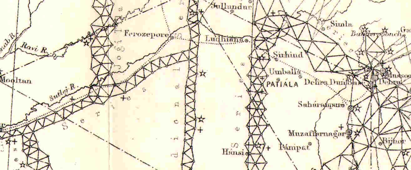
(My interest in maps and map-making recently led me to some amazing material on the great trigonometric survey of India Wikipedia's page about it. The image is a tiny part of the overall project. "Simla", what we today call Shimla, is in the upper right. Each intersection on the curious webs of triangles was a survey station, from which the bearings along the lines radiating from it were measured. With incredible accuracy. The webs spanned, literally, the length and breadth of India, being done mostly in the 1800s... and for most of the 1800s, as well. As you might have guessed, I have written my own page about the great trigonometric survey of India. I was also lucky enough to acquire for my collection a beautiful copy of a map of India, based on the survey, from about 1890, thanks to the excellent dealer Tim Bryars, in London.
I have done a "menu" for you of links to reports with photos on trips to other destinations. (It will open in a new window or tab.)
If you find yourself wanting to use a photo on this site, please see my page about using web-published material which is copyright TK Boyd. If you want to contact me, here's my eddress, or you can use the contact form. (Email best, as the contact form is often abused, and I don't read all messages arriving that way.) Corrections to bad information on the pages very welcome... don't be shy!
![]()
Page has been tested for compliance with INDUSTRY (not MS-only) standards, using the free, publicly accessible validator at validator.w3.org. It passes in some important ways, but still needs work to fully meet HTML 5 expectations.
AND tested for valid CSS
