India February 2014 with Tropical Ice
Itinerary in Detail
This is just one participant's account of the Tropical Ice "Passage to India" trip of 23 Feb-13 March 2014. Nothing here should be take as "official"... or even necessarily as accurate! You should also assume that Tropical Ice will refine the program, in the light of experience and new opportunities. They certainly did a good job of being adaptable to circumstance during our adventure with them.
This page is an account of what we did on the trip... day by day. If you don't want so much detail, you may prefer the treatment at the trip report's main page.
The page has a "history"... apologies if there are lapses in the editorial process.
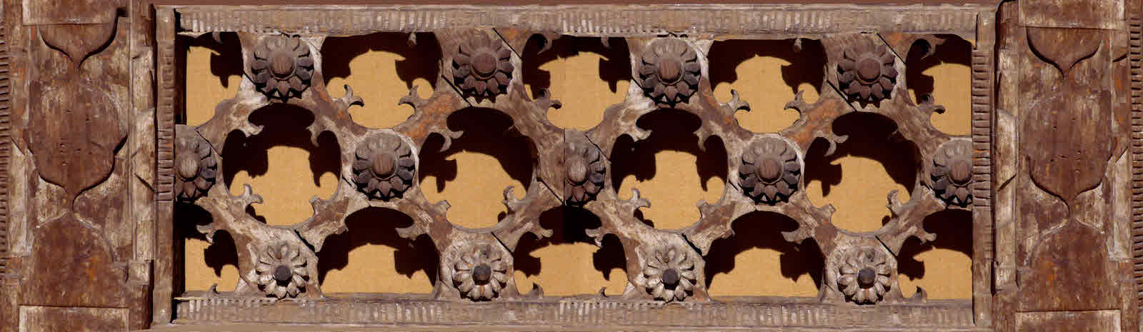
By the way... do you like the "banner" photo of the antique wooden screen, at the top? More on this in a moment.
For a zoom-able map, with way-points giving information about our trip, visit the Google "My Places" map I've created. In the scrollable column of text to the left of the map, there's detail about what each pin markds.
Going back to the decoration at the top: Until you read this, did anything seem "strange", or "wrong" about it? You'll find out why I ask if you read the rest of the page!
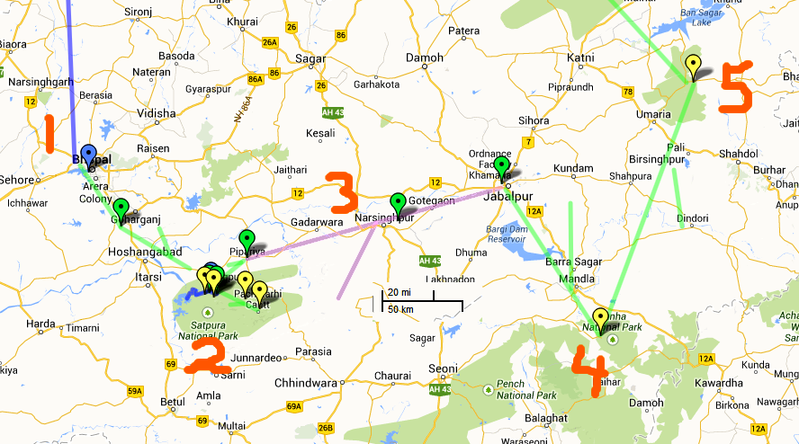
The following map covers a bit of "central" India. You can see where it is in the overview on this site's index page, if you don't happen, for instance, to know where Jabalpur is.
Imperial Hotel, Janpath, New Delhi. I stayed here on my wonderful trip to India in 2004, and will be delighted to return. A luxurious start to the trip.
Late in the day, after enjoying sights in Delhi (Chandri Chok and Qutb complex) during the day, we flew down to Bhopal ((1 on map.. the blue line represents our air travel from Delhi. "Bhopal" is lost under the blue pin.)), spent night at the Jehan Numa Palace, ready for a good start the next day.
En route to our "base" in the Satpura National Park ((2 on map)) (and tiger reserve), we visited the Bhimbetka Rock Shelters (-WP-) (That indicates a link to a Wikipedia page. Such links will open in a new tab or window, just close it to get back here)... a UNESCO World Heritage site, where there is hominid archaeology 300,000 years old, and "cave" paintings from 30,000 years ago.
To put those datings in perspective: Homo sapiens only began to exhibit full behavioral modernity around 50,000 years ago. (Wikipedia))
The region was at one time known as "Gondwana". That name is also applied to one of the two "super-continents" which were all the earth had 200 million years ago. I guess that the geologist concerned thought of this region as old?
After Bhimbetka, we drive on, to end the day at the Denwa Backwater Escape... deep in the park, on the north bank of the Denwa River.
The day was to have started with a quick boat trip across the Denwa, to elephants waiting to take us for about an hour's travel into the park... but a spectacular thunderstorm cancelled that plan... but a game drive in the park was rescheduled. (See March 1st).
Instead, we checked out of our lodge, and started off on the trip's main "walking adventure"... but first traveled two hours by vehicle to just outside Pachmarhi, in the middle of the flat top of one of the main "hills" in the Satpura range.
The day's hike was "only" about five miles... don't laugh, those of you who know how many days it takes me to accumulate five miles of walking in the course of my usual life... but during those five miles we descended about 500m from about 1000m on a high plateau. The views: Stunning!
I was actually able to partake in this hike, and enjoyed it. No trouble with back. No trouble with being out of breath, over-heating, etc. Yes, knee was twinging a bit by end, but not enough to even bring on a limp. Just a warning to be careful.
The nights of Feb 26-28 were under canvas, away from "civilization".... but it was very nice canvas, I expect.
(This part of this page still needs post trip editing, and I am running out of time for this session. I can quickly insert here that it was at dinner on the 26th that I discovered my knee worse than I'd realized. THAT passed in about 18 hours, thankfully. But the urge to vomit that started just after dinner lasted about six hours... with no helpful result... and problems in the other direction began. Lasted in earnest about 36 hours. I generally travel without incident. I'm careful. Once before a few days of mild nausea. Nothing like this in YEARS. Was collapsed in bed... when not on my for-a-time regular visits to latrine and shower... sorry... TMI?... for all of next day, quite weak. Two bad nights... and then there was the storm... and even Cipro, when I finally enlisted it, didn't seem to make much speedy difference. AND THEN collapsed into one of my "allergy" melt downs... runny nose. Happily, Imodium and Benedryl got me through times when I needed to be "out and about". Better living though chemistry, hurrah! But about 48 hours of the trip are poorly recorded, and I missed two days of walking. I DID manage the walk-out on March 1st! (^_^)
There were two hikes out from and back to where we spent the night for the nights of 26/27 and 27/28... a very nice sand bank above a small river. As related above... I missed them.
A hike of about 10 miles, west down the Denwa's valley. At the end of it, the walkers were given a lift (45 minutes) to our new home under canvas. I (and two others) did the journey between camps by vehicle.... fascinating to see the "behind the scenes" work done by the army of people making our enjoyment possible... and fascinating to spend several hours in a very "rural" village, near where our came was.
One final short hike, a little over 3 miles, of which I was able to partake... thank you Immodium... and then vehicles took us back to the Denwa Backwater Escape by about noon.
In the afternoon, we took a boat across the water, from our lodge in the "buffer" zone of the park, into the "core" zone, and went for the game drive which was rained off on the morning of the 25th.
Do you like steak or ice cream? Originally we were to have done the visit on elephant back, which has its charms, but for the re-scheduled tour, 4x4s were the transport available....
Which probably made all the difference. We were able to cover more ground. And in Satpura, a long established reserve, the wildlife seem indifferent to the 4x4s. (Tigers will allow people to approach very close, on elephants. And elephants "do" off road well.)
We saw a pack Indian wild dogs, the dhole. Only a glimpse, but... (more on this later). And we had a marvelous encounter with a sloth bear and her cub. Ditto.
The official itinerary drolly remarks that this is "a long travel day". But it also says "But so much to see". True... on both counts. You want to visit the two best placed to see tigers? Look at the map. You will have a long travel day. Worth it. Good drivers. Good vehicles.
First a drive. Then a train journey ((3 on map in mauve)) ... if you haven't seen television programs about the Indian train service, you have missed a treat. I was looking forward to the train experience, and was not disappointed. (And I have traveled by train in India before, but in a more modest way.) Then more driving. We were glad to see our hotel. I think "pushing through" like this is worth it, as opposed to "wasting" a day to do the journey more gently.
On the Google "My Places" map I've created to support this page, there's a "pin" for a bit of interesting engineering we passed during the train trip.... and I forgot to look for! Sigh. You have to zoom in quite a lot, "satellite" view, to see it.
Night of March 2nd, and several to follow: Kanha Earth Lodge ((4 on map)). Believed to be at 22.26743, 80.48709 .... but aerial image at Google Maps taken before lodge built, if so! (As of 18 Mar 14, 15:27, anyway! Bing seems to show something here that is, I think, the lodge.)
I had a rude re-discovery: There's a 4:30 in the "morning", in additon to the sensible one in the afternoon, created for tea- the ceremony and pause for relaxation and sugar level adjustment.
We'd traveled a long way to see tigers. They are nocturnal and shy. So we got up at 4:30, went out, relied on our local experts to hear signs of alarm in the forest, and to get us quietly "settled" in The Right Place, to watch the forest in the last stages of the night, as the early light brings the night to an end.
Then we took a break in the middle of the day... which I never managed to use for the rest it would have been good for... and then we did it again from mid afternoon to late evening, hoping to catch the tigers at the start of their "day".
(Actual timing, on one drive BACK to lodge, from Kanha: 25 minutes park gates to lodge)
(Above to be moved)...
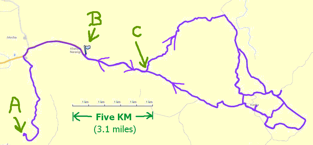
Map of our drive to and in Kanha, 3 March, finishing 6:30 GPS (Zulu) time. Started GPS tracker half way to gate, 12:56 GPS time.
A: Kanha Earth Lodge
B: "New" ("Current" entry point to reserve... yes! It is expanding!
C: Site of old gateway to park, with Rest House built 1910.
So... we drove in and out along road from gate to rest house... though the park's "buffer zone". Then round, and round and round, on the roads you see. What you don't see is that we often re-traced a given road in the network. Unlike Botswana: No going off road if the animals have chosen to be coy. Probably a good thing, where the tourist pressure is as high as it is in Kanha. "the meadow, beloved of readers of Schaller's book, in region of two small "loops", eastern end of our peregrinations.
High noon can be quite warm. We can sleep then, and do it all again the next day. This will be our pattern in Kanha, and again at our next destination.
I "know" the Kanha reserve from the excellent book "The deer and the tiger", Schaller. (You may have to be a biologist to love that book... but I am. (It is a semi-popular account of a year's research at Kanha.))
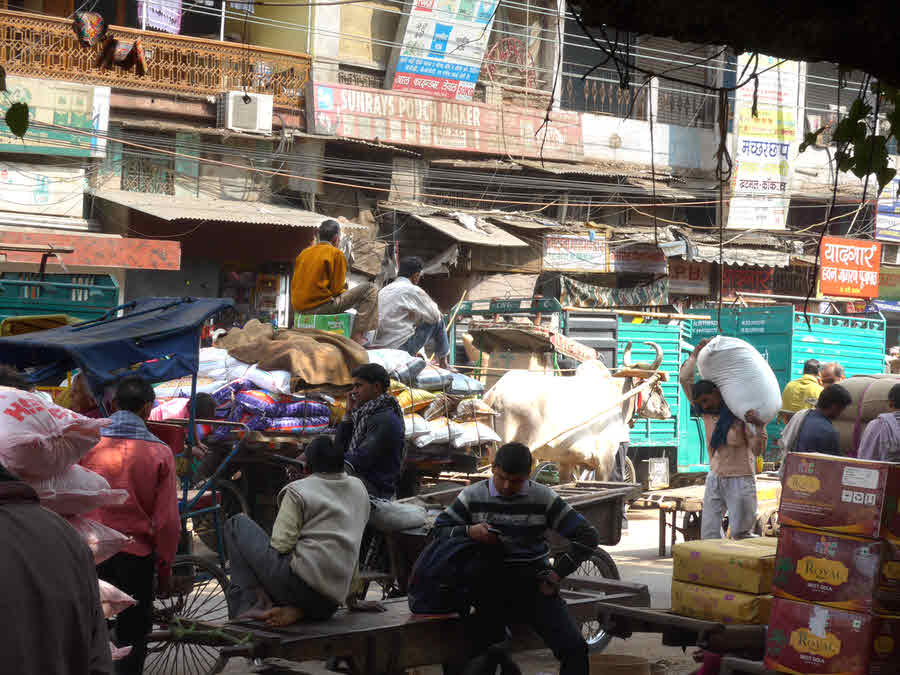
About a six hour drive. Fascinating, if long. India is not all teeming cities! Most fascinating? People trudging along the road in "the middle of nowhere". From were had they come? Where were they going?
Night at King's Lodge, ((5 on map)) on the edge of the Bandhavgarh Tiger Reserve. Night of 5th and some after it.
In Bandhavgarh Tiger Reserve. I thought I "knew" this one from some very good natural history programs on TV, but I think they were filmed elsewhere. It IS the site of one of the stations of the Great Triangulation.
King's Lodge- similar "days" (04:30 start) as at Kanha, same reasons. Happily, a shorter drive from lodge to tiger reserve gate. Only 25 minutes, or so, at Kanha... but at either end of long drives, a long 25 minutes.
The plans called for us to get to lie in! Up "late": 5:30! And at 10:15 the night before, we learned that the plane we had to catch would be delayed, and we got another hour (or so? more?) EXTRA lie in!!
Visit Khajuraho Monuments Group (Wikipedia link) en route.
UNESCO World Heritage site. Hindu and Jain temples from around 1000AD
After temples, at about 15:00 (planned... was later), fly to Delhi.
Night at The Imperial... a justly legendary hotel, but the time we had... even if our flight hadn't been delayed... to enjoy it made the drive in (and back to) the airport seem more than it was worth?
Estimated departure from hotel, Delhi ((1 on map)): 08:00
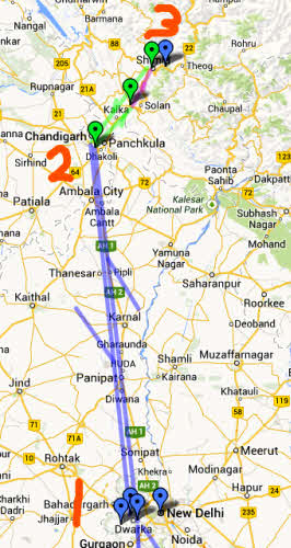
Flight from Delhi to Chandigarh ((2 on map)). Estimated: 09:50am-10:35
March 9 mid day: Drive for about 2 hrs from about 11am
Board train to Shimla ((3 on map)), roughly 4 hrs on train. Line colors tell you what mode of transport we are using.
The train is special! This is the famed "Hill railway to Shimla" (Wikipedia link). Narrow gauge. Steam until 1971. Shimla is high enough to stay cool in the Indian summer, and has long been a "retreat" for those able to afford it. British occupied from early 1800s... I have a photo of a great uncle here in about 1920. The train dates from 1898. Steam until 1971. Amazing views, as it climbs the flanks of the Himalayas to 6,811 ft.
Arrive Shimla about 5pm March 9th, then about 45 min drive to Wildflower Hall for first of several nights there.
(This section still needs more post-trip editing... sorry...)
Day hikes out and back, March 10 & 11
Visit town of Shimla, morning of 11th.
About 17:15 board plain for 45 minute flight to Delhi.
Night of 12 March at airport Radisson.
In my case, my flight departed at an easy 13:55, and two people I'd become particularly friendly with were on it. Arrived London 17:55. Sadly, those times are local... the flight is rather more than four hours.... fancy nine and a half hours in a plane? I'm glad the tigers cooperated! Even if they hadn't, which was entirely possible, I'm sure I would still be saying it was a wonderful trip. I've wanted to go back to India ever since my first visit to that beautiful and fascinating land... and this trip did not disappoint.
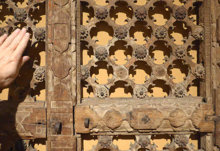
Oh! The decoration at the top! The image was created using Serif's PhotoPlus, starting with a photo I took of a wooden screen in the National Museum, in Delhi....
Ah- The power of photo manipulation tools!
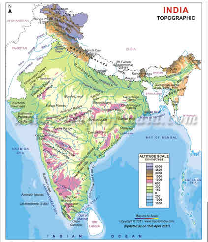
Forgive me sticking this in here... I'll try to think of a more logical spot in due course. There's a rather nice topographical map of India online, at a MapsOfIndia.com site, if you want to get a "feel" for the subcontinent. I'm only publishing a thumbnail here, as their views on non-profit use of their map are not clear.
Want to look closely at some image? To zoom in on just bits of it? I explain how, and give some other browsing tips on the linked page.
If you came to this page by clicking on one of the links on the trip's main page, you can just close this tab to return there.
If you find yourself wanting to use a photo on this site, please see my page about using web-published material which is copyright TK Boyd.
![]() Page has been tested for compliance with INDUSTRY (not MS-only) standards, using the free, publicly accessible validator at validator.w3.org. Mostly passes. There were two "unknown attributes" in Google Translate and Google+ button code. Sigh.
Page has been tested for compliance with INDUSTRY (not MS-only) standards, using the free, publicly accessible validator at validator.w3.org. Mostly passes. There were two "unknown attributes" in Google Translate and Google+ button code. Sigh.