(Filename: roy-baseline-book.htm)
(To get all the beauty of that, right-click on the image, open it in a new tab and zoom in. ("Ctrl" plus "+" in Firefox))
In the 1700's maps were pretty crude.
In Britain, William Roy was an advocate of doing something about this. Eventually, he launched a magnificent effort.
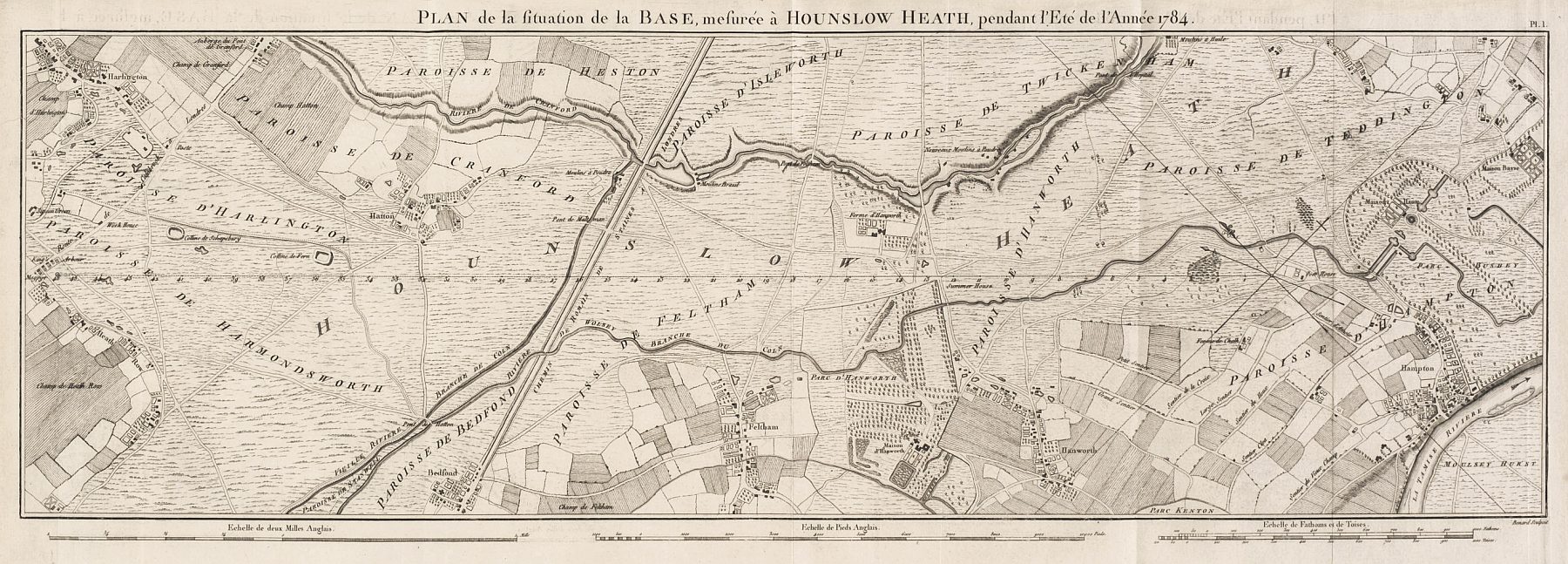
And at the heart of the effort was the measurement of a line from about where Heathrow Airport is to a point about 5 miles to the SE of there.
Some soldiers measured it for him very carefully. This was in 1784. Their answer was 27,404.01 feet.
The line was re-measured in 1791. (This was the first work of the then newly established Ordnance Survey. Captain William Mudge was in charge. He ended up a Fellow of the Royal Society, and a Major General.)
Mudge's team found the distance to be two and three quarters inches longer.
The baseline was measured again in 1858. This time the answer obtained was 27,406.19 feet.
-----
So, "on top" of a "basic" 27,404.01 feet, you either add 2.76 or 26.16 inches.
-----
I'll repeat that: When this distance of about five miles was measured three times, the difference between the shortest answer and the longest was two feet and two inches.
Two feet two inches is the distance from my nose to the tips of my fingers if my arm is stretched out horizontally in front of me, fingers outstretched. (I am 5' 10" tall. (178 cm))
(Who says? I used what was at https://www.ordnancesurvey.co.uk/newsroom/blog/heathrow-airport-honours-the-work-of-major-general-william-roy, accessed 27 Aug 22 as the basis for that "they were very close" material.)
The mapping was a joint venture between the English and the French. Astronomers were very anxious to have an accurate measurement for the distance between the Paris and London (Greenwich) observatories.
As I say, the mapping depended in part on having a good measurement of a baseline. (There's more on all of that in my Make Your Own Map pages.)
When Roy had finished his fabulous measurement of the baseline, it was written up, for all to examine. Were there any flaws in how they had done it? (Apparently not! But the report was still a necessary part of the scientific method.)
As a project of interest on both sides of the Channel, the report was, quite reasonably, translated into French.
This page, when finished, will have some further notes relating to the report. For now, here is some material arising from the map that is a part of the report.
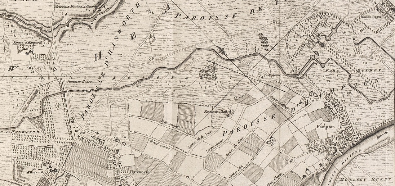
(It is at 51.42641, -0.36571... a place about 5 miles SE of Heathrow Airport.) Note that these images do NOT have North at the top. "Up" is NE on them.
On bit of the map shown, the baseline runs horizontally across the middle of the image, from about 1/3 of the way across, starting from the right hand side. It starts in the middle of the "X", which is a compass rose. You can see the usual device marking "North". (The map seems to show both magnetic and "true" North.) The baseline is marked, right to left, "1", "2", "3",... "16".
(Should I have annotated the image, to show you all of that? I didn't want to deface it. Use your words!)
It is never wise for me to start looking at maps.
"Nothing to do with" Roy's baseline, really... but look at 1784 "Bushey" and 2021 "Bushy Park"... it's just to the right of the south end of the baseline. (SE of it, if you remember that these maps do NOT have North at the top. (The top is towards the NE)
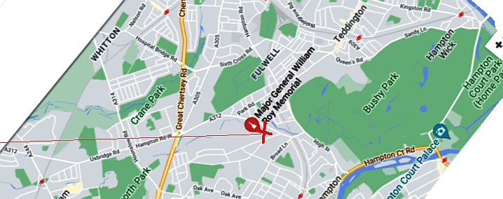
But first! A wider context... The red "+" is the SE end of Roy's baseline... shown rather more elegantly on his map, I fear! The thin red line going to the left of that is the baseline, headed off, eventually, to Heathrow.
I hope you'll have fun matching up the roads and other features, then and now...
(Here's a page with more information, graphics, etc, combining these maps. It also gives a "Gimp" (free photo manipulation software) lesson.)
---
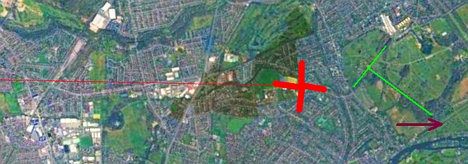
And now Bushey/ Bushy Park.
Hampton Court is "just off the page" in the previous image, by the way... the dark red arrow points towards where it is.
The green "T" in the previous image is where the long avenue of trees in Roy's map is, and the ornamental ponds. It is repeated in the more magnified image below. It doesn't seem that "we" have taken very good care of our heritage, does it? Sigh. But at least you can still see traces of the ponds.
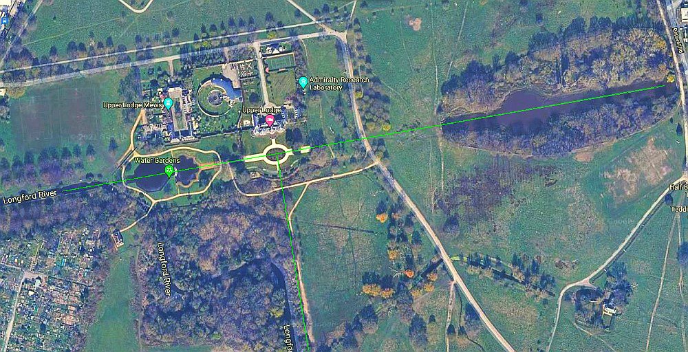
Oh dear... and then there's... a webpage to tell you a bit about the background of the Admiralty Research Lab... no longer at Bushy Park, but I think the circular feature comes from the days when it was.
... and... some of the history of the Lodge.
Apparently it has been given over to property developers. At least one can hope that a few up-market hamster cages will result. I wonder how much of the parkland will disappear under the never ending pillaging, conversion to acres of 2 and three bedroom "homes" on postage stamps. Ah well.
Search across all my sites with the Google search button at the top of the page the link will take you to.
Or...
Search just this site without using forms,
Or... again to search just this site, use...
The search engine merely looks for the words you type, so....
*! Spell them properly !*
Don't bother with "How do I get rich?" That will merely return pages with "how", "do", "I", "get" and "rich".
I have other sites. My Google custom search button will include things from them....
One of my SheepdogGuides pages.
My site at Arunet.
![]() Page has been tested for compliance with INDUSTRY (not MS-only) standards, using the free, publicly accessible validator at validator.w3.org. It passes in some important ways, but still needs work to fully meet HTML 5 expectations. (If your browser hides your history, you may have to put the page's URL into the validator by hand. Check what page the validator looked at before becoming alarmed by a "not found" or "wrong doctype".)
Page has been tested for compliance with INDUSTRY (not MS-only) standards, using the free, publicly accessible validator at validator.w3.org. It passes in some important ways, but still needs work to fully meet HTML 5 expectations. (If your browser hides your history, you may have to put the page's URL into the validator by hand. Check what page the validator looked at before becoming alarmed by a "not found" or "wrong doctype".)
AND passes...
