 This is Sky. "skywoof.com" is named for her. (^_^)
When I asked Alexa what the highest mountain in the world is, she said "Everest". Which is, after all, the "right" answer.
But "highest mountain" is not as simple as you may thing.
I grew up beneath the Rocky Mountains. They are a treasured part of my soul.
If you go to Nepal... which I highly recommend in general, you will see MOUNTAINS. Including, of course, Everest.
But if you go to Alaska, you can see a "bigger" mountain. (I'll get to the islands of Macaronesia in a minute, in case you are wondering.)
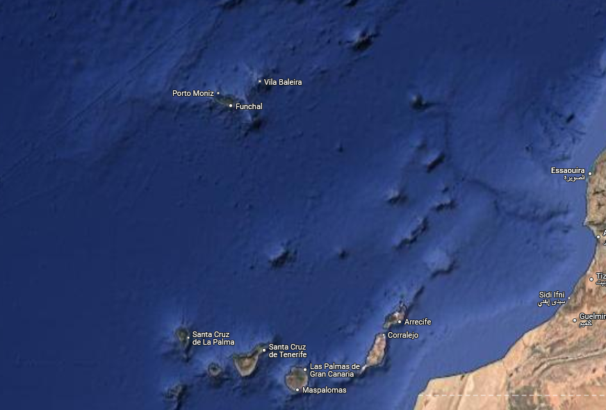
(I came to write this essay due to things I learned about on an excellent expedition with National Geographic/ Lindblad. You don't need to know anything about that trip to follow the discussion below, but if you are interested, I've written an account of visiting Macaronesia... Cabo Verde, Canaries, Madeira, Azores.)
Almost none of the numbers in the essay are absolute, other than the height of a mountain or island above sea level. Please get in touch if you find egregious errors, but I did spend about three hours trying to get good numbers for the rest.
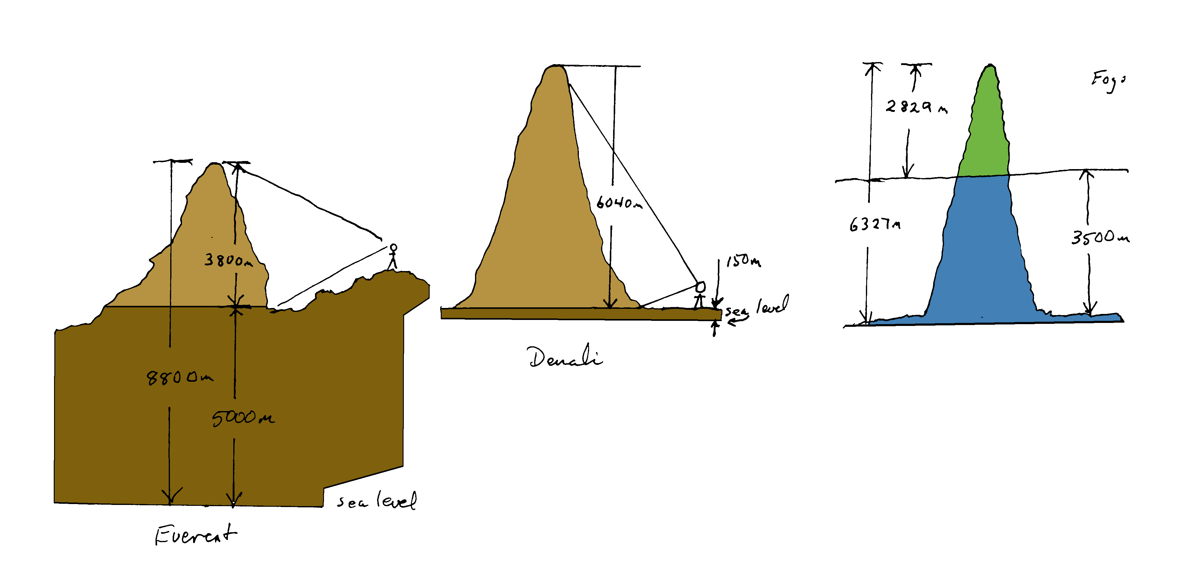
In Nepal, there are points not far from Everest that are 5000m above sea level. If you stand where you can see one of those "low" points and Everest at the same time, you will see about 3800m of that breathtaking mountain. It's bulk, and the giants around is are as easy to describe to you as it would be to describe the sea to someone who had never seen it.
But if you go to Alaska, and stand "near" Denali in Talkeetna, you will see about 6040m of mountain. It is only 6190m (above sea level) high... but Talkeetna is only 150m above sea level. (I've had to make the representation a bit "too big" in my diagram to make it easily visible!)
Now we come to the islands. Above the sea, they are impressive. The one we saw on Tenerife in the Canaries was 3715m high (above the sea). Almost as much mountain as you see if you visit Everest. (But no where near as bulky, and all on it's spindly own. Don't worry that Tenerife will displace Everest in climber's hearts!)
But, as is the case in Hawaii, where this story is better known, there is very deep water around the islands. Immediately around the islands. They lie well offshore, slender pillars rising from the deep abyss. Perhaps the following, apart from being beautiful, will give you an idea of how it is.
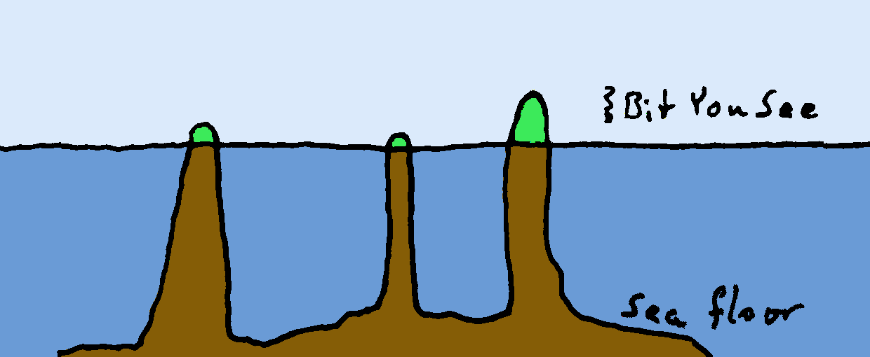
The broad "flat" places are 4000-5000m deep. A car going 60 miles per hour needs about two and a half minutes to travel 4000m.
Notice how few, far between, and spindly the "stickie uppie" bits are. They are frozen lava from old volcanoes. The ones that stick up enough are the islands; the others are called sea-mounts, of which more another time.
Most of the islands we visited were, even to someone who started life in Colorado, pretty nearly "mountains".
But if you were to measure the "height" of the islands from the sea floor in it's immediate neighborhood, you'd get really impressive numbers. More on this on a moment. But first...
Maybe you've seen things like the following?
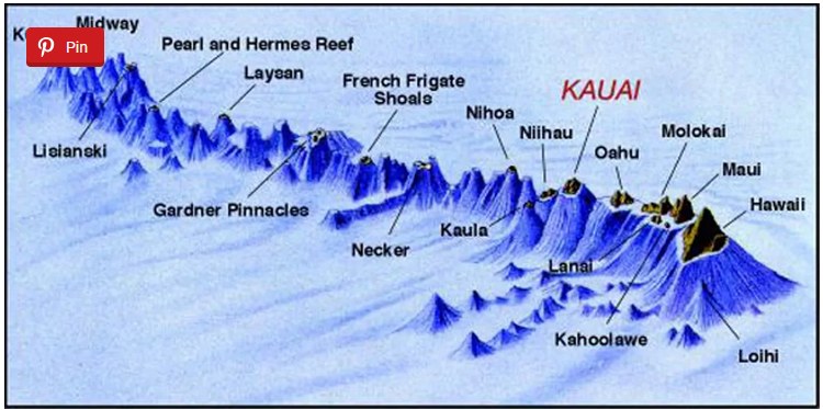
That was the image in my mind for many years, certainly... tiny bits of the volcano above the surface, many, many more meters of volcano below the surface.
Alas, as delightfully dramatic as that picture is, I think the story is more usually less extreme. I say "I think" because what figure is the right figure for "depth of ocean floor near the base of the island" is not an easy number to pin down. (If you want to make your little gray cells sweat hard go to Wikipedia's page about topological "prominence".)
Whether the above water/ below water ratio is dramatic or not, the overall height (sea floor to summit) of the islands is impressive.
The following diagram tries to show why you might call Denali the "highest" mountain in the world. And it shows what one of the islands we visited (Fogo, in Cabo Verde) looks like when you can see above and below the sea.
I've drawn Everest, Denali and Fogo all to the same scale. The light brown is the bit of the mountain you can see, the dark brown is the rock between the lowest part you can see and sea level. In the case of Fogo, the "above the sea" part of the volcano/ island is the green part, and the submerged part is blue.
So, sadly, the islands are not like this...
I apologize for all the words... but after many hours pulling this together, I couldn't resist. Sorry. I hope I didn't obscure the wonder of some of the matters covered.
What is meant by "sea level"? That is not nearly as simple as it might seem!
Search across all my sites with the Google search button at the top of the page which will open in a new tab if you click this link.Or...
Search SheepdogGuides.com site, including Flat-Earth-Academy...
|
What's New at the Site / / Advanced search
This search tool (free to me and to you) is provided by FreeFind.com... whom I've used since 2000. I'm happy with them... obviously!
Unlike the clever Google search engine, FreeFind's merely looks for the words you type, so....
* Spell them properly.
* Don't bother with "How do I get rich?" That will merely return pages with "how", "do", "I"....
Disclosure: FreeFind tells me what people have searched for. It doesn't tell me your personal details. (If someone would "spy" on you, wouldn't they also feel free to lie in a "privacy statement"? Not to say I'm not lying... how can you tell?... but to say "What are privacy statements worth?".
The search engine merely looks for the words you type, so....
*! Spell them properly !*
Don't bother with "How do I get rich?" That will merely return pages with "how", "do", "I", "get" and "rich".
Please also note that I also have other sites, and that the FreeFind search will not include results from them. They each have their own site-specific search buttons.
My "wywtk.com" site...WhatYouWantToKnow
My "skywoof.com" site...
This is Sky. "skywoof.com" is named for her. (^_^)
And there are links from those pages to pages at my SheepdogGuides.com, Arduserver.com and Flat-Earth-Academy.com sites, which are also controlled by me.
https://www.arunet.co.uk/tkboyd/ My oldest-still-running site*. Have a laugh at some dated material! It may be dated in styling, but not all of the content is obsolete. Much of what was there is also available at https://skywoof.com/aru/index2.htm (*My Compuserve site is, alas, history.)
To email this page's editor, Tom Boyd.... Editor's email address. Suggestions welcomed! Please cite the page's URL, "fea/geo/highest-mt.htm".
![]() Page has been tested for compliance with INDUSTRY (not MS-only) standards, using the free, publicly accessible validator at validator.w3.org. It passes in some important ways, but still needs work to fully meet HTML 5 expectations. (Copy your page's URL to your clipboard before clicking on the icon, so you can easily paste it into the validator when it has loaded.)-->
Page has been tested for compliance with INDUSTRY (not MS-only) standards, using the free, publicly accessible validator at validator.w3.org. It passes in some important ways, but still needs work to fully meet HTML 5 expectations. (Copy your page's URL to your clipboard before clicking on the icon, so you can easily paste it into the validator when it has loaded.)-->
AND it has been tested with...

![]() Why is there a script or hidden graphic on this page? I have my web-traffic monitored for me by eXTReMe tracker. They offer a free tracker. If you want to try one, check out their site. Neither my webpages nor my programs incorporate spyware, but if the page has Google tools, they also involve scripts. Why do I mention the scripts? Be sure you know all you need to about spyware.
Why is there a script or hidden graphic on this page? I have my web-traffic monitored for me by eXTReMe tracker. They offer a free tracker. If you want to try one, check out their site. Neither my webpages nor my programs incorporate spyware, but if the page has Google tools, they also involve scripts. Why do I mention the scripts? Be sure you know all you need to about spyware.
. . . . . P a g e . . . E n d s . . . . .