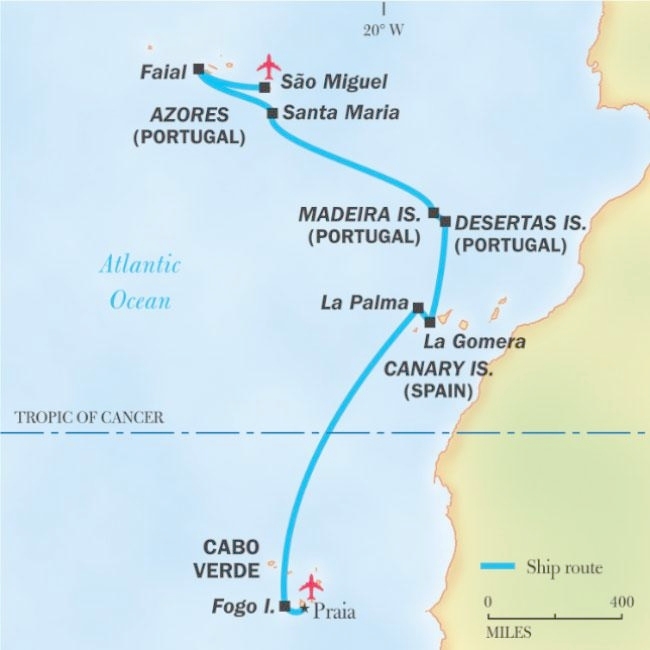
The map above is our expedition as planned. A storm passing through between the Canaries and Madiera (2 days at sea for us) would have made the passage tedious had we done that on the days originally planned. We made an extra stop in the Canaries, visited and extra island in the Madeira group, and missed out Santa Maria and Faial in the Azores. These changes saved us being at sea in nasty weather.
It was a minor matter for the guests on the trip... and a remarkable feat of trip-restructuring by the people running the expedition. We were provided with full programs including transport, local guides, meals, etc. on islands that we weren't even going to visit just a few days before we arrived.
Besides this page, I also offer an account of our day-to-day doings.
In a nutshell... Flew from home (England) to Lisbon. A day there. Flew to Cabo Verde. Lived on ship from there to go to Canaries, Madiera, and Azores. Flew back to Lisbon. More Lisbon time. Back home!
Before I go on... most of the maps here were created by me from images fetched from Google Maps. I worked hard! It was only much later that I realized that I had a copy of the above from the tour operator's website. It's better than mine, I know... but I don't want to re-write this page or discard the work I did. Sorry!
Getting back to my story of the expedition!....
Until the late 1700's, sailors could not be sure of their longitude- how far north/south they were.
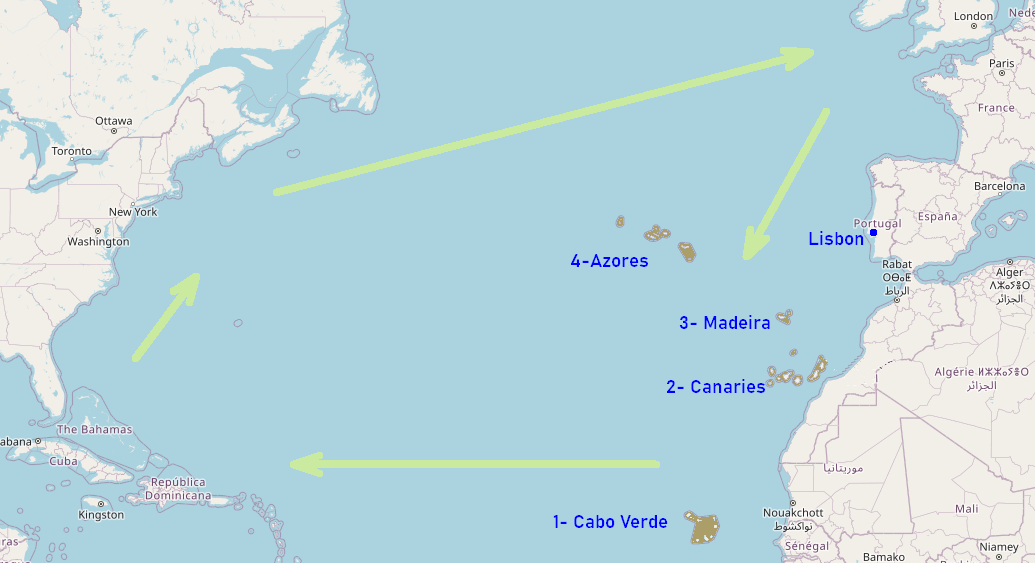
Because of logistics, wind patterns and the navigation benefits, ships going west to the New World would sail DOWN this chain of islands (we'll be going UP them) and then set off west along a longitude. (Accurate determinations of longitude were possible. Not latitude.)
My sister and I had an excellent trip with Lindblad / National Geographic Expeditions. (The maps were derived from what is available at https://www.openstreetmap.org)
Lindblad Expeditions has been offering expeditions to Antarctica for more than 50 years; they pioneered tourism in that wondrous place under the leadership of Lars-Eric Lindblad. If they can manage Antarctica, I'll trust them to take me other places.
For much more detail, see my "Intinerary" page.
-----
April 17th, 2025, before the organized expedition began, my sister and I flew from our homes to Lisbon, Portugal, and enjoyed that lovely city before flying to Cabo Verde ("1" on the map above). (Ignore the green arrows for now!)
April 19-21, Days 1,2 and 3 of the expedition were spent in Cabo Verde.
Note how far south that is. It is well below Morocco, only 15 degrees north of the equator. As far south as Guatemala's capital city.
Days 4-6 were at sea, en route to...
Days 7-9 the Canary Islands ("2").
Days 10-11 were spent at sea, and visiting the Desertas Islands, arriving at the main island in Madeira in the evening. ("3")
Day 12 Porto Santo Island, in the Madeira group...
Day 13-14 at sea, en route to...
Day 15-16 Ponta Delgada, Séo Miguel Island, Azores... from whence we flew back to Lisbon, late on day 16.
Day 17-19 were in Lisbon. Left for home the morning of Day 19, May 7th, 2025, and was back at my house by mid afternoon.
That's the big picture. The next section, the last section for this page, gives greater detail.
Before modern ships, and modern navigational tools, in particular the marine chronometer, it wasn't wise to try to sail directly from Europe to the Caribbean. The green arrows show the routes they used, for the reasons given below...
The prevailing winds weren't helpful for that plan, and also it was easy to lose your way out on the wide Atlantic.
However, the navigational tools available back in that time were enough to keep a ship on a particular latitude. (The equator is a latitude. The other lines, the ones from pole to pole, are the longitudes.)
So what captains did was to sail down the chain the of Atlantic Islands we will be visiting, until they reached the latitude of the Caribbean. Along the way, they often took on board a "cargo" of enslaved people.
When they reached the right latitude, they turned west, and sailed along that until they reached their goal.
This "go southwest, then east" plan also gave the ships better, more dependable winds. The ships of the day were much better at running before the wind than at tacking upwind.
And last, perhaps not least: Ships were small in those days. Running out of provisions, in particular drinking water before you reached land was a danger. The route they used (shown by the green arrows) make the leg across the Atlantic shorter.
Sailing up the east coast of North America wasn't hard, because they could stay not far from land. Also, they wanted to visit Newfoundland to take on board salted fish... a major part of the diet of the enslaved people growing sugar for the Europeans. (See Kurlansky's book, Cod: A Biography of the Fish that Changed the World.)
Favorable winds, and a suitable longitude to follow brought the ships back to the start of the circuit.
Note that the enslaved people were having to live on salted fish which had crossed the Atlantic twice. Tillable land in the Caribbean was too much needed for growing sugar to "waste" it on growing food for the enslaved people.
Kurlansky's book "Cod" is where I learned about the cod.
I found Hick's book, "Voyage to Jamestown" interesting on the question of navigation in the early 1600's. To quote from the Goodreads page, it "features a fictional crew and ship"... but those parts of the book are "carefully reconstructed from actual accounts and people". (It also has straightforward explanations of tools and techniques.)
(I can unreservedly recommend https://abebooks.com (or abebooks.co.uk) as the place to go to get any book you could possibly want... from a copy of a Coben thriller to a first edition of Darwin's Origin of species. Easy to use website. Good service. Sort the reults you are given by price, to find the best bargain currently on offer. If what you want is too expensive just now, you can also "create a want" and they will email you when there's a new listing for something you want.)
April 17, 2025: Departed London Gatwick, 14:50, on 2hr 40min flight, TAP, to Lisbon, Portugal. I'd been told often that Lisbon is a great tourist destination, but I'd not been there before. I enjoyed it.
April 18: Fun in Lisbon with my sister, who flew in that morning.
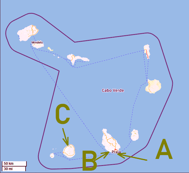
EXPEDITION DAY 1 (April 18): Left Lisbon 9am on TAP for 4hr 20min flight to Praia (a), on Santiago Island- Cabo Verde
The "official" start of the expedition was in Praia.
National Geographic/ Lindblad call their programs "expeditions" to stress that they are different from mere "cruises". I consider the distinction to be valid.
Night in hotel.
The big map at the top shows how far south Cabo Verde is... it is well below Morocco! Only 15 degrees north of the equator. As far south as Guatemala's capital city. (Hence the long flight!)
You may know Cabo Verde as "the Cape Verde Islands". Today the nation is known as Cabo Verde (in the local language and in English), so I have used that name here. (I had a similar "problem" on an earlier expedition with Lindblad when I went to Svalbard, which is a better name than Spitsbergen. (The latter is just the main island in the group.))
The maps of the island groups are all shown at roughly the same scale, so you can appreciate their relative sizes.
DAY 2: Walking tour of Praia. Visited Ribeira Grande (b), another city on Santiago Island. Boarded our ship, and set off towards...
DAY 3: Fogo Island (c), Cabo Verde.
DAYS 4-6: At sea. Crossed Tropic of Cancer.
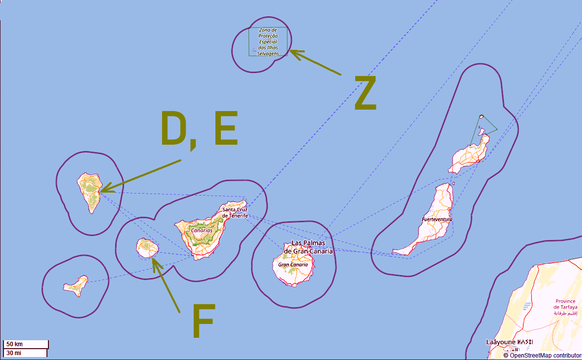
DAYS 7-8: La Palma (d) and La Gomera(f)- Canary Islands, Spain. Drove up to Mirador de la Concepcion (e).
Large parts of these web pages were created before I went on the cruise. And up to here, that was okay- things went according to plan.
Alas, "Man proposes, God disposes".
Had we stuck with the original plan (embark on a long open sea crossing on the 9th), we would have crossed in a severe storm.
The National Geographic/ Lindblad team did a great job of teaking our plans. On day 9 we made a visit to Tenerife.
That is also in the Canaries... but doesn't have a letter in my diagram. It's the island immediately to the east (right) of "F", La Gomera.
So... at short notice... the National Geographic/ Lindblad team arranged a berth for us in Tenerife, planned mulitple trips on the island to make the visit worthwhile. Arranged local guides. Hired busses. Booked large parties into restaurants. And all of these big tasks were done well. I was very impressed... and grateful to be spared the hard crossing!
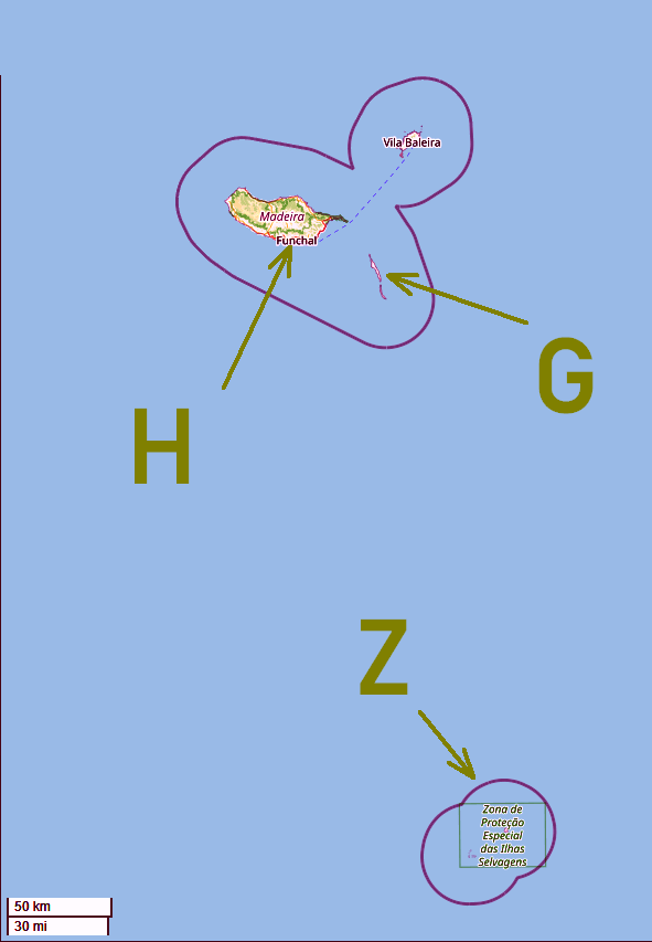
DAYS 10-12: At sea, then Desertas Islands (g), Funchal, Madeira (h) and Porto Santo Island. (It, like Tenerife, doesn't have a letter on my diagram. It is the small island NE of Madheira.) These islands are part of Portugal. (Porto Santo was another bonus due to the storm... but also part of why we didn't visit all the islands we had planned to visit in the Azores.)
The "Zona Proteao" (z) in the "peanut" shape near the bottom of this map for the Desertas and Madeira appears at the top of the map for the Canaries, showing you how close they are to one another. (Madeira is north of the Canaries.)
DAY 13 and 14: At sea, en route to Azores.
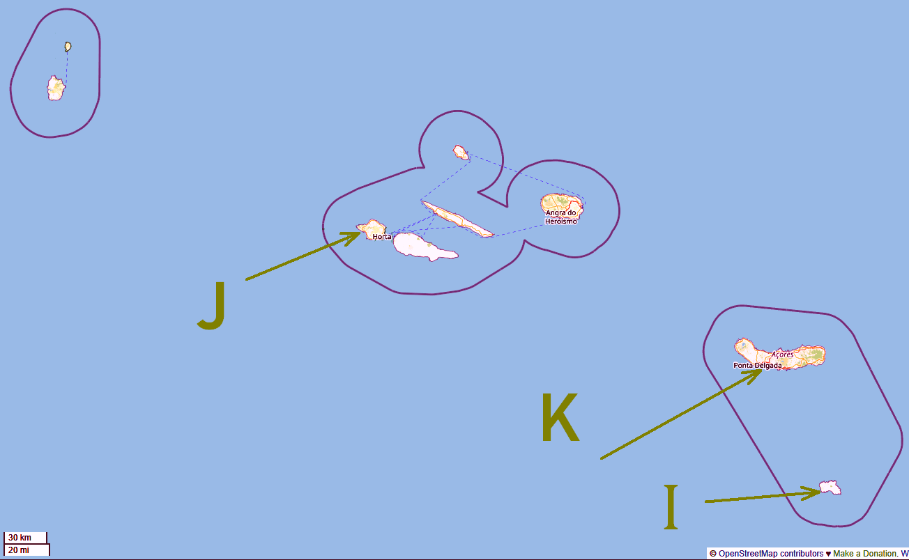
This is drawn to about the same scale as the others. (The tiny scale indicator in the lower left shows 30km/20 miles in this image.)
Sadly, we only visited "K", the island of Seo Miquel, the consequence of the wise decision (and hard work) which added bonus visits elsewhere and avoided a long sea crossing in foul weather. (These maps were done in anticipation of the planned trip.)
DAY 15: Ponta Delgada, Seo Miquel Island, Azores- Portugal.
DAY 16: Ponta Delgada (k), Sao Miguel Island, Azores. Disembarked, transferred to airport. Expedition over.
In the early evening of Day 16, flew back to Lisbon, Portugal, traveling independently again.
DAYS 17-18: Playing in Lisbon
DAY 19: Departed from Lisbon 10:00 flight to LHR.
Search SheepdogGuides.com site, including my trip reports...
|
What's New at the Site / / Advanced search
I have other sites. The Freefind search will not include them. They have their own search buttons.
My SheepdogSoftware.co.uk site.
My "wywtk.com" site...WhatYouWantToKnow
Or use the Google search box/ button at the top of this page to search across all my sites.
This page's editor, Tom Boyd, will be pleased if you get in touch by email. Suggestions welcomed! Please cite "SheGui/tr/atlan25/atl-itin0.htm".
![]() Page has been tested for compliance with INDUSTRY (not MS-only) standards, using the free, publicly accessible validator at validator.w3.org. It passes in some important ways, but still needs work to fully meet HTML 5 expectations. (Copy your page's URL to your clipboard before clicking on the icon, so you can easily paste it into the validator when it has loaded.)-->
Page has been tested for compliance with INDUSTRY (not MS-only) standards, using the free, publicly accessible validator at validator.w3.org. It passes in some important ways, but still needs work to fully meet HTML 5 expectations. (Copy your page's URL to your clipboard before clicking on the icon, so you can easily paste it into the validator when it has loaded.)-->
AND it has been tested with...

![]() Why is there a script or hidden graphic on this page? I have my web-traffic monitored for me by eXTReMe tracker. They offer a free tracker. If you want to try one, check out their site. Neither my webpages nor my programs incorporate spyware, but if the page has Google tools, they also involve scripts. Why do I mention the scripts? Be sure you know all you need to about spyware.
Why is there a script or hidden graphic on this page? I have my web-traffic monitored for me by eXTReMe tracker. They offer a free tracker. If you want to try one, check out their site. Neither my webpages nor my programs incorporate spyware, but if the page has Google tools, they also involve scripts. Why do I mention the scripts? Be sure you know all you need to about spyware.
. . . . . P a g e . . . E n d s . . . . .