One of the joys of travel, for the thinking person, is the way it sets the mind on fire with new ideas.
This page is quite "raw" at this point... but I was keen to make a start. Many of the things here have only been "roughed in". There's much more to be said.
So far, it mostly raises questions. In due course it will discuss answers to those questions.
You may feel that the questions are absurd. Fine. Your loss. Not everyone understands the fun to be had with playing with ideas, trying to solve puzzles for yourself, instead of just asking Google. No one is making you read this page! (I hope. If schoolchildren somewhere have been given it for homework, my sympathies... but try to "enjoy" it. These things CAN be fun...)
They say the earth is (nearly) a sphere. How do YOU know this is true? Do you just believe anything you are told? Wouldn't it be more fun to find a way to know it is true, from your own experiences? And what does a trip to Svalbard (this page is part of a report about such a trip) have to do with those questions?
They say the earth goes around the sun. Look out the window for a day or two. The sun OBVIOUSLY goes around the earth, if you just watch it! Where does this other idea come from?
What is "a day"? What is "noon"? What is "a year"?
There is a "right" answer to each of those, which no sensible person would contest.... but the questions are nothing like as simple as they seem.
Where do day and night come from? Why is the time between sunrise and sunset variable? How does it vary... in other words, if I told you that you were in Lima, Peru, and that it was May 5th, when would sunrise and sunset be?
How "high" in the sky is the sun? What further parameters do you need to specify before someone can give you an answer? How would you measure it, if I asked you "how high is it, here, now?"? This simple question does not have a simple question. The whole matter of how we measure things is a huge and vitally important topic, with many chapters. If you get in touch, I would be interested in how extensively you can outline the contents of the book "Measuring" which has been written many times, because of the topic's importance.
What does "direction" mean? How do you measure it? "North" is an incomplete answer. And even if you are facing one of the norths, there are several ways to say "that" direction... some of them unconnected to "north".
In Denver, Colorado, if there's even moonlight, you can always say where west is... you are facing west if you are looking at the mountains. If the mountains went away, and you had a rough idea of the time, you could still tell directions. Around noon, if you face the sun, you are facing roughly south. This isn't always true. When, where is it NOT true. Why?
In Svalbard, the sun was always "up", when we were there in June. So there was no way to know the time from how long the sun had been up.
If you knew the direction you were facing at a particular moment, that would tell you the time. Alternatively, if you knew the time, you could tell where north was from where the sun was. How? (That's two "how"s to answer.)
As I said... this is just a rough outline of a page I might develop, if anyone shows interest. Giving the page Facebook "likes", Google "Plus"s, etc, or contacting me are ways to "show interest". I hope you will, and I hope you will enjoy the results.
There more "stuff" below, but it is just more initial sketches of things to come; it isn't "complete".
Maybe "a day" is how long it takes the earth to spin once? (If you have decided the earth is a spinning sphere... another question to be explored!)
When the hands of an (old fashioned, "analog") clock go around the dial twice, that's "a day". (But the more you can leave out things you can't make or prove yourself, the more fun the exercise becomes.
But, I mentioned the clock face to raise another problem... if you say "a day" is the time for the earth to "go around" once... how do you know when it has got back to "where it started"?
(Digression: "I read on the internet"... don't take to bank... but maybe an interesting(?) exercise in fact checking: Earth orbits sun at 30 km/s. Star orbits center of galaxy at 250 km/s. Galaxy moving through universe at 600 km/s. And earth spinning, too. How fast are you spinning? (Depends on your latitude, doesn't it?)
Is a day from sunrise on "day one" to sunrise on "day two"? Sort of. Roughly.
But... if you are in Svalbard in June, you'd better find another definition of "day". "Sunrise" is hard to pin down (! (another topic)), and there is one "day" by the "sunrise to sunrise" definition which lasts months.
Is a day the time from noon today until noon tomorrow?
What is "noon"? Like "day", that is not as simple as you might wish.
Questions, questions! I will eventually write some answers... but the fun, for you, is going mostly to be in the looking for answers. I don't want to rob you of the fun.
A ways back, I asked if you could figure out what you'd need to be able to answer "When would sunrise and sunset be in Lima, Peru on May 5th?"
You can't answer that until you define what is meant by sunrise. THAT isn't as simple as it seems... not if you want to be able to give a precise time for "sunrise". What has to be pinned down?
If you don't have a precise definition, if one person says "Sunrise is at 8:04:23" and another says "It is at 8:06:15", they could both be right... depending on what they meant by "sunrise". I once knew a fun family who watched the sunset from their garden... and then dashed upstairs to see the sun set again! Try it. Can you run up the stairs fast enough?
By the way, if the sun "sets" at 19:00:00, by that time, the sun is actually quite a bit below the horizon... the light has taken 8 minutes to travel to us, remember... during which time the earth has turned further.
Once you have defined sunset, you may find that it is very hard to measure accurately when it comes. Unless you are at sea. (That's a hint, by the way, concerning many elements of what we are discussing here.)
Pity the poor clockmaker: In some eras, in some lands, "an hour" was 1/12th of the time from sunrise to sunset. So a winter hour was shorter than a summer hour. (And night hours were long when day hours were short, and vice versa. And the precise length of an hour changed every day.)
Much of our ruminations have connections to the vast topic of sundials.
On Svalbard, a sundial would only work for part of the year... but it would work all day long during that part of the year, if set up properly.
What would a sundial for the Svalbard summer look like?
Could you make a "moon dial" or "star dial" for clear skies in the winter months? The answers are yes, and yes... but they are different answers. Which is the easy one? How would such sundials be made? What would you need to set them up? You can do it without access to a modern timepiece, by the way. Harder... but it can be done.
Once you agree that the world is (roughly) a sphere, we can begin long explorations of how to "name" places on that sphere with a system that works for the whole sphere. (Yes... it is easy to name, say, "Boston" as "Boston", and people in the neighborhood will understand what you mean when you say "I will be in Boston Thursday". But I want a system that works across the whole world, and is not ambiguous. (There are actually at least two Bostons, for instance.)
"Of course", YOU say, "the answer is latitudes and longitudes". But they (lat/ long) are relatively recent "inventions". Think... as you did about "day". There are lots of questions about what latitudes and longitudes are, let alone how you would measure them, mark them on a globe, etc. THINK about what those questions are... in detail. It is so easy in "learning" to forget to think about "what was the question?" "What, in 'the big picture' does knowing this tell me?"
Once you agree a lat/ long system... it took a while to do that (until 1884)...think about how, absent a GPS device, you can figure out the lat/ long of where you are at the moment?
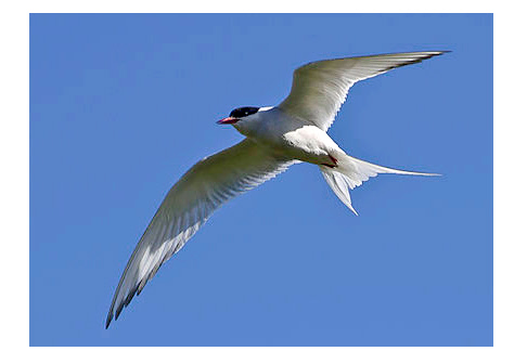
Without a lat/ long system, how do you make large scale maps? (I haven't got an answer to that one... it was rhetorical.) How do you provide a sailor with a chart which will take him, say, from the antarctic to Longyearbyen in Svalbard, without hitting any rocks poking out of the sea along the way. (ditto) Remember: The arctic tern (photo from Wikipedia) isn't the only thing to migrate back and forth between the poles... the ship we were on does it too.
I'll give you the start of an answer to the "maps" question: you go out, stick a durable post in the ground, and find the lat/ long of that place. We'll call that place "post A". You make a dot on a piece of paper. You then measure... very carefully... a straight line to another place, put a post in the ground there, measure the angle between the line between the posts and the line to magnetic north. And put another dot on your piece of paper. Now you have a map! If the line was 5 miles long, and you put the dots 5 inches apart, your map's scale is 1 inch to the mile. If you put the dot in a sensible place, then magnetic north on your "map" is towards the top of the page. (There's also a "true" north. So "north" can be looked at quite closely at some point.)
Wow! A map showing the location of two posts!
Doesn't seem like much, but that was the starting point of all the maps for the UK until the mid 1960s. And similar exercises underpinned the good large scale maps elsewhere. The posts were stuck in the ground in 1784, and replaced by 16' long old cannons (more durable, 14' buried, muzzle up. Hit that with your lawnmower and it isn't going to be the "post" that is damaged.)) in 1791.. and you can see them today. (One is on the north side of Heathrow airport, just outside the security perimeter, thank heavens.)
Once you have the two posts, and your two point map, you start marking in things you can see from the posts. And then things you can see from the things you could see from the posts. Etc. Until you have a "proper" map!
If you've done the same thing somewhere else, and you know the lat/ long of a point on each map, you can "join them up" based on the lat/ longs.
How do you do the posts thing accurately? How can you check your map's accuracy? I have several web pages elsewhere about how they did it. There are some pages aboutmaking maps yourself, using the techniques used for the important maps which came out of the 1700s, 1800s. How close can you come to what "they" did? (Quite close, as it happens. How?) There's a page about an amazing achievement in the field in the mid 1800s... the determination of Everest's height... from 106 and more miles away.
The earth spins. Got that. It spins (about) 365 times in the course of orbiting the sun once. But are you clear on the DETAILS of the angle between the axis of the once- a- day spin and the plane of the big orbit? It is ABOUT 90 degrees... but not exactly. And that "detail" has HUGE consequences for Life On Earth, and many of the things we've been considering on this page.... not least the very fun "midnight sun" thing.
In haste... I will move this in due course, give you a chance to think about your own "answers" first, but...
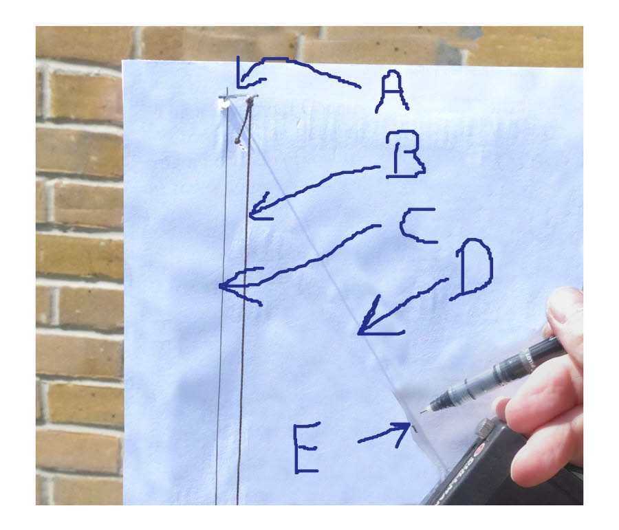
The diagram shows one "instrument" for measuring how high the sun is in the sky. It has strengths and weaknesses. What are they? What other instruments are possible. What are their strengths and weaknesses?
A: A pin, stuck in a bit of paper, protruding at a right angle. From it hangs....
B: A bit of thin black string, with something on the end to pull it taut, "down".
C: A line drawn on the piece of paper.
To take a reading, you old the paper/ string up and adjust it until the string lies over the line, and the sun is casting....
D: A shadow of the pin across the paper. You then...
E: Mark where the shadow of the pin lies. From that, you can work out the angle of how high the sun is in the sky.
Any angle is about the "corner" where two lines meet. In the case of the illustration, the angle of the vertical line and the line of the pin's shadow is about 30 degrees.
Subtract that from 90, and you know the angle of the sun above the horizon, about 60 in the case of the illustration.
Look at it. Think about it. See how it shows that the sun is (about) 60 degrees above the horizon.
The measurement in the photo was done at 11:43 local time, 24 June 2016, at a location in England 50.84 degrees north of the equator. It measured the sun as 59 ° above the horizon. At 13:23, the angle was 62 °. Solar noon was 13:06, according to the internet. How would you find solar noon for yourself? What IS solar noon?
With a similar instrument, I made similar readings in Svalbard. Not enough!... but these are what I have...
Date/
  Time.. by Oslo time zone (also applies Svalbard, 2 hrs ahead of Zulu)
          Degrees above horizon
2016
June

13   22:34    16 degrees

??   20:??    19 degrees (Some details missing!)
14   22:33    22 degrees
15   12:29    32.5 degrees
16   11:45    34 degrees
16   14:28    ALSO 34 degrees
13   22:34    16 degrees
And lastly, on this "how high", in Oslo, 12 June, 11:57 (local), sun was 51 ° above the horizon. Almost as high as it was when checked in Chichester (See above). How can that be?
Lots of food for thought, if you are Right Thinking.
And, in related new, I have yet to write up some numbers about the other sun angle... how far "around" the sky it was at different times. South of us around noon.... north of us around midnight... in theory. Did measurements support the theory, or are there other factors to be figured in? (Of course, elevation and azimuth, what we've been talking about, are not the only way to describe the sun's position in the sky... but they are a useful way. WHY "useful"??
Remember... this is incomplete. I hope you are enjoying it already. Answers to the questions welcomed! Unless you say "please do not publish", I will assume that you will be happy for me to put some of your ideas on the page. Please include diagrams, etc, as jpgs?
Facebook "likes", etc, even more welcome!
I've tried to discuss these things before. There's a lot of overlap between the above, and the corresponding material in my Flat Earth Academy, Astronomy Department pages. If the above was of any interest... and you're still reading, aren't you?.... maybe check the Flat Earth Academy pages out? They didn't range as widely as the above... but the "answers" there are more complete, the pages more polished. (Yes, I know... they could hardly be less polished!)
(If you came here from the Top Page, it is probably still open "under" this one. Just close the current tab, and you should be returned to the Top Page.)
![]()
Page has been tested for compliance with INDUSTRY (not MS-only) standards, using the free, publicly accessible validator at validator.w3.org. It passes in some important ways, but still needs work to fully meet HTML 5 expectations.
AND tested for
