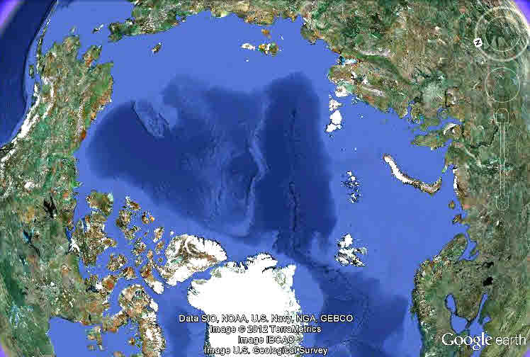
Pop quiz! What's this?.....
(Scroll down for answer and comment....
v v v v
v v v v
v v v v
Tell the truth... how quickly would you have said "the top of the world", if you hadn't come here from a polar bear trip's account? And how long did it take you to find Norway on the right, Alaska upper left? Hudson's Bay, where I went, is the first body of blue you come to when you move along the bottom from the left hand edge. The big white area is the top of Greenland.
The maps we grew up with are misleading. The best known examples are the distortions of Greenland (not as big as it looks on "normal" maps), and Africa, which is much larger than usually shown.
The map above is a pretty fair representation of the Arctic Ocean, and the shores around it.
Pause a moment and think about the world from this point of view, especially as a biologist.
The Arctic Ocean is, though bigger and colder, not unlike the Mediterranean Sea: A body of water, surrounded by land. And the lives of organisms on the land in, say, northern Russia, is not so different (or far away from) the life of organisms in northern Canada. (The differences between the African and European shores of the Med do not arise between different Arctic shores. Think about it, you should be able to see why.)
Now let's "slip down the globe" into Canada....
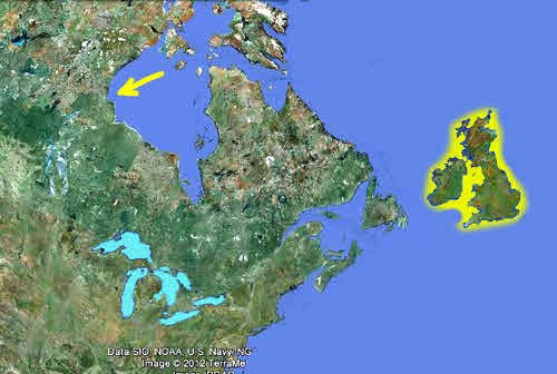
With the wonderful help of Google Earth, I've been able to put together something which lacks much of the distortion you see on more usual maps.
I've picked out the Great Lakes in cyan, to make them easier to see.
The map shows the relative positions of New York (at the bottom edge), London (half way "up" the globe to where Churchill is) and Churchill (indicated by the arrow).
And yes, Hudson's Bay and James's Bay between them are about the size of the UK.
You are thinking about what all this means, aren't you? Short winter days/ short summer nights. And all that leads on from there.
Hudson's Bay, by the way... not Hudson's Lake. Salt water. Whales. Shipping route. (In summer grain leaves the Canadian prairies via Churchill and the sea... a large part of the economic base of Churchill.)
Winds and currents cause the water in the bay to circulate counter-clockwise, by the way. Important to all of the life there.
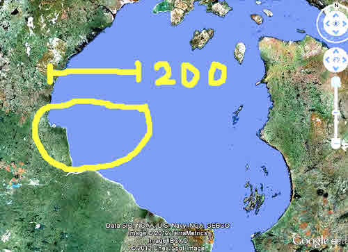
This may not be the shape you were expecting for Hudson's Bay... but is it more true-to-life.
The yellow circle shows the approximate range of the group of bears which lives near Churchill in the summer and autumn. Churchill is at the western end of the small bit of east/west coastline. The bar is about 200 miles long.
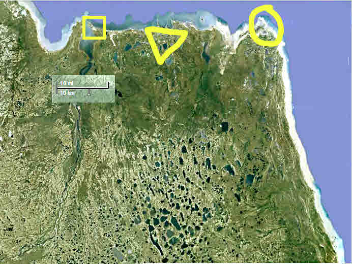
We've zoomed in again. From the square to the circle is about 35 miles. This is the bit of east/west coastline I pointed out in the previous map.
The square is the town of Churchill, shown in detail in the next map. Between it and the triangle, you can see the airport... which was one of the space shuttles alternative landing sites, having an exceptionally long runway in a part of the world not over-served by airports.
The triangle is where the Northern Studies Center is, which I discuss in the page about the biologist's work.
The circle is where I had my first bear encounter. More on that elsewhere. Our other bear encounters were along the coast to the south of there.
Before we move on, look at the lines in the earth's skin in this photo. There's a north running river about 20% from the left edge. Then, if you look, you can see "lines" in the lakes in the bottom half, middle section. The lines are not quite north/south, they lean a little to the left. These are "scratches" left by the glaciers. And along the north/south coast on the right hand edge, you will see multiple "beach" lines....
I think! At least those are my guesses! I haven't studied a text on the geology of the region, and all of that is informed speculation!
One more point, before we move on. Go back to the previous map. Why the little "step" in the coastline, the bit of east/west shore which interrupts the otherwise mostly smooth sweep of the bay's western shore?
If you go to.... http://en.wikipedia.org/wiki/File:Canada_geological_map.JPG ... you will find a geological map which will help you understand. Whatever the underlying geological reason for the "bump" in the coastline, I strongly suspect that it is no coincidence that a major bear population... one of the 19 in the Arctic... lives here. They need the ice, to get out to their food. And with the circulation in the bay being what it is, when you get ice here is affected.
(The "Geology" section at... http://en.wikipedia.org/wiki/Hudsons_bay .. is interesting. Sadly, no evidence exists for the idea that either the bay or the Nastapoka arc (the 160 degree, near perfect segment of a circle, at the southern end of the eastern shore, is a flooded meteor impact crater.
And so to our last map, the immediate area of Churchill. The items picked out here will mean more to you when you've read other pages at this site, but here we go....
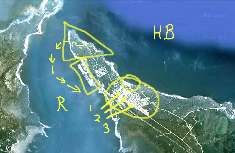
The triangle encloses Point Mary, a gorgeous place we went out to in the late afternoon of our first day. Very atmospheric, and the possibility of stumbling across a bear added to the romance.
"HB": Hudson's Bay
"R": River.
The line of arrows is our flightpath on the occasion of seeing the beluga whales.
The rectangle encloses the big granary.
The circle encloses the bulk of Churchill.
Our fine lodgings were at "1", the Polar Inn and Suites.
At "2" is where you will find the wonderful Gypsy's Bakery and restaurant. http://www.gypsybakery.ca/ "The place to be", in Churchill. (6am to 10pm.. and happy to serve us late.)
At "3": The home of our helicopters.
(The big airport is to the east of the area shown in the map above, as is "Miss Piggy".)
The little circle inside the bigger circle is where a filming session on a beach was "in bear country".(More on that on it's own page, which isn't yet published, unless I've forgotten to remove this note!
This page © TK Boyd 5/12. Click here to contact him.
This is one of the sub-pages from my report of my visit to Churchill, where you can go if you have an appetite for more!
You are also invited to Tom Boyd's homepage, including Windows software for schools, kids, and others.
![]() Page tested for compliance with INDUSTRY (not MS-only) standards, using the free, publicly accessible validator at validator.w3.org. Mostly passes. There were two "unknown attributes" in Google+ button code. Sigh.
Page tested for compliance with INDUSTRY (not MS-only) standards, using the free, publicly accessible validator at validator.w3.org. Mostly passes. There were two "unknown attributes" in Google+ button code. Sigh.
- - - Page ends - - -